UK
UK Ireland
 Scotland
 London
Precision Utility Mapping
Telephone
Click to view
Mobile
Click to view
Website
Contact
Steven Lannon
Email
Address
3c Langlands Square
East Kilbride
Scotland
G75 0YY
Scotland
About Precision Utility Mapping
Precision Utility Mapping is committed to providing the most detailed and accurate utility surveys. Our primary business focus is, and always will be, utility locating, 3D utility mapping and GPR surveys. This allows us to be fully focused and committed on being the best utility survey company in the UK and Ireland.
By combining the workmanship like quality of a small company with the standards and safety procedures of a large multi-national company, Precision Utility Mapping can provide the most detailed surveys to our clients.
Through rigorous in-house training and external certification, we can guarantee that our technicians are the most highly trained in the industry. Combine this with investment in the most up-to-date equipment available, and you have the foundations needed to provide the best possible service to our clients.
Precision Utility Mapping provides all clients with a safe working environment through the accurate location and mapping of underground services. We have accreditations from CHAS, Constructionline and Achilles that verify our policies and insurances are compliant with current regulations.
All of our technicians are put through rigorous training and assessments prior to being approved utility surveyors. Our in-house training is complemented by accreditation from ProQual, which ensures that our technicians are properly trained and competent. This is followed up by regular site audits, quality-assurance checks and continued training updates.
Precision Utility Mapping cannot operate to the high standard we provide without the cooperation of our staff. It was with this in mind that we decided to become a living-wage supplier. This commitment was made as we believe that everyone is entitled to a wage that reflects the true cost of living. Our people are important to us, and a happy work force will inherently provide a better service to our clients.
If you would like more info on the living wage, please don’t hesitate to contact us or visit www.scottishlivingwage.org for more details.
Services
Utility Surveys - Precision Utility Mapping UK
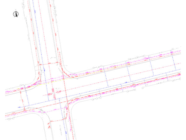
There are various different standards of utility survey, but they all strive to achieve the same thing: to accurately find and map the location of all underground services, and voids, within a specified area.
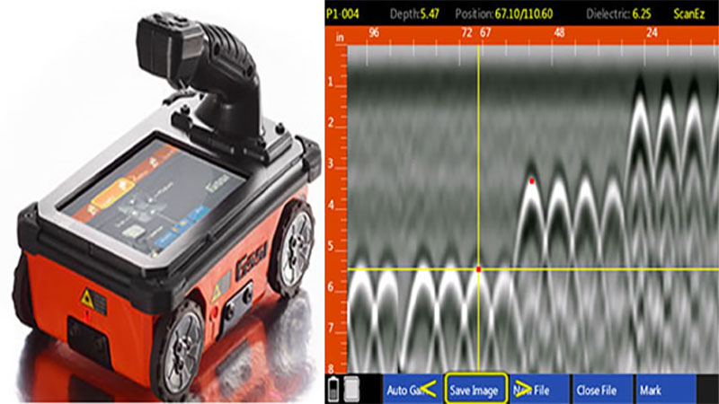
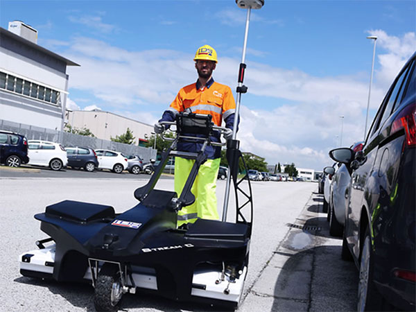
Precision Utility Mapping utilises the latest in EML (Electro-Magnetic Locators) and GPR Survey (Ground Penetrating Radar) equipment to ensure that our surveys are of the highest quality. We are fully qualified to carry out PAS128 level surveys, and have vast experience working to RICS and TSA utility survey standards. We are also able to tailor our underground utility surveys in order to offer a solution that best fits the need of the client.
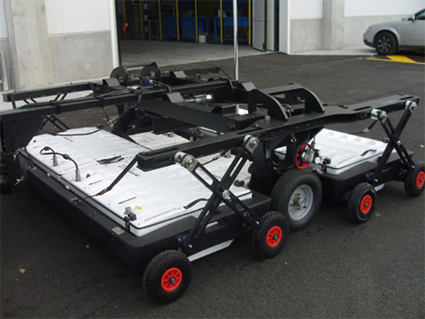
Mobile GPR - Precision Utility Mapping
Mobile GPR (Ground Penetrating Radar) is a quick, efficient way of gathering a large amount of survey data, which can either be used in conjunction with a normal utility survey to better identify areas of high congestion or in areas where restrictions limit the time you have on site to gather data (Airport Runways etc.).
The information gathered on site is processed in the office and converted in to CAD output. If used in conjunction with a utility survey, the two sets of data can be merged to check the accuracy of the survey and also fill in any blanks left by utilities that cannot be located using EML (Plastic Gas & Water Mains, Voids, Foundations, etc.).
Mobile GPR is usually towed behind a vehicle, which means less traffic disruption when gathering data.
Structural & Concrete Scanning - Precision Utility Mapping
Precision Utility Mapping offer a solution, also known as a concrete scanning, to see what’s contained within solid surfaces including concrete and walls.
Concrete scanning is non-destructive, so allows the detection of concealed objects, reinforcement steel, post tensioning, cables/conduits and voids without the need to break the concrete out. This helps to prevent hazards or costly problems involved when coring or drilling in to concrete or walls.
Using the latest handheld scanner from GSSI allows us to scan up to 50cm through concrete.
By combining the workmanship like quality of a small company with the standards and safety procedures of a large multi-national company, Precision Utility Mapping can provide the most detailed surveys to our clients.
Through rigorous in-house training and external certification, we can guarantee that our technicians are the most highly trained in the industry. Combine this with investment in the most up-to-date equipment available, and you have the foundations needed to provide the best possible service to our clients.
Precision Utility Mapping provides all clients with a safe working environment through the accurate location and mapping of underground services. We have accreditations from CHAS, Constructionline and Achilles that verify our policies and insurances are compliant with current regulations.
All of our technicians are put through rigorous training and assessments prior to being approved utility surveyors. Our in-house training is complemented by accreditation from ProQual, which ensures that our technicians are properly trained and competent. This is followed up by regular site audits, quality-assurance checks and continued training updates.
Precision Utility Mapping cannot operate to the high standard we provide without the cooperation of our staff. It was with this in mind that we decided to become a living-wage supplier. This commitment was made as we believe that everyone is entitled to a wage that reflects the true cost of living. Our people are important to us, and a happy work force will inherently provide a better service to our clients.
If you would like more info on the living wage, please don’t hesitate to contact us or visit www.scottishlivingwage.org for more details.
Services
- Utility Surveys
- Mobile GPR
- Structural & Concrete Scanning
Utility Surveys - Precision Utility Mapping UK
There are various different standards of utility survey, but they all strive to achieve the same thing: to accurately find and map the location of all underground services, and voids, within a specified area.
Precision Utility Mapping utilises the latest in EML (Electro-Magnetic Locators) and GPR Survey (Ground Penetrating Radar) equipment to ensure that our surveys are of the highest quality. We are fully qualified to carry out PAS128 level surveys, and have vast experience working to RICS and TSA utility survey standards. We are also able to tailor our underground utility surveys in order to offer a solution that best fits the need of the client.
Mobile GPR - Precision Utility Mapping
Mobile GPR (Ground Penetrating Radar) is a quick, efficient way of gathering a large amount of survey data, which can either be used in conjunction with a normal utility survey to better identify areas of high congestion or in areas where restrictions limit the time you have on site to gather data (Airport Runways etc.).
The information gathered on site is processed in the office and converted in to CAD output. If used in conjunction with a utility survey, the two sets of data can be merged to check the accuracy of the survey and also fill in any blanks left by utilities that cannot be located using EML (Plastic Gas & Water Mains, Voids, Foundations, etc.).
Mobile GPR is usually towed behind a vehicle, which means less traffic disruption when gathering data.
Structural & Concrete Scanning - Precision Utility Mapping
Precision Utility Mapping offer a solution, also known as a concrete scanning, to see what’s contained within solid surfaces including concrete and walls.
Concrete scanning is non-destructive, so allows the detection of concealed objects, reinforcement steel, post tensioning, cables/conduits and voids without the need to break the concrete out. This helps to prevent hazards or costly problems involved when coring or drilling in to concrete or walls.
Using the latest handheld scanner from GSSI allows us to scan up to 50cm through concrete.
Gallery
Location Map
Precision Utility Mapping Serves The Following Areas
Precision Utility Mapping Serves The Following Towns
Find Precision Utility Mapping in
Precision Utility Mapping Branches